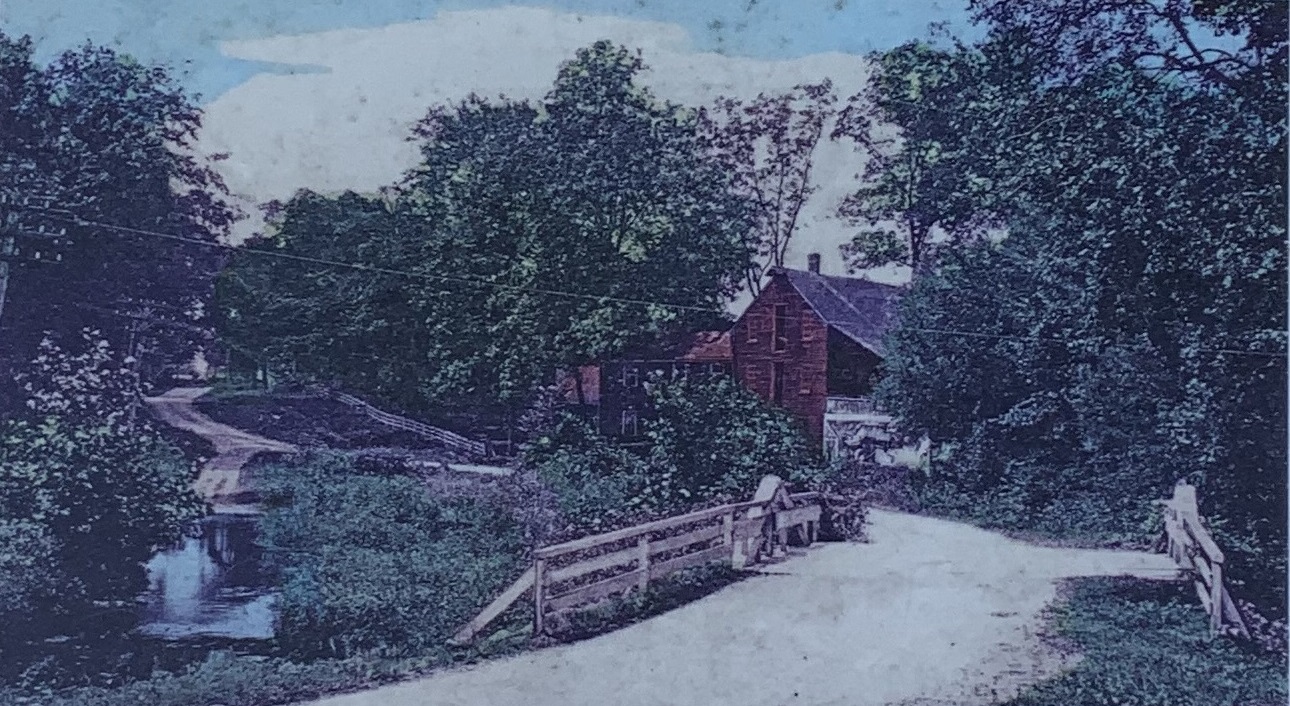
1894 photo of the Old Red Mill, enhanced by the Norwalk Historival Society and displayed at Brookside Cemetery on Rowayton Avenue. Shot southwesterly from the Norwalk side of the Five Mile River bridge. In the foreground, the non-macadamized old Post Road (called the Farm Road in the 1900 census) crosses an A-frame bridge over the river. The road winds past the grist mill up the hill toward Raymond Street.
The mill building is center right. The mill run and wheel are under the roof on the right side of the building. The mill is three stories high. At the top is a hoist that would lift grain to the top floor.
Two utility poles can be seen at the far left. They would surely have included telegraph and telephone wires. And, the first municipal electric plant in Connecticut began operating in South Norwalk in 1892. Between the utility pole and the bridge is the mill run flowing back into the Five Mile River. To the left of the mill is a house built in 1880 that today is 222 Old Kings Highway North. A long white fence parallels the road toward Raymond Street, probably starting in front of the house. See Unenhanced photo |
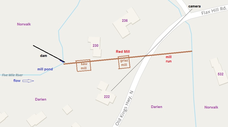
Rough sketch on a Mapquest map of where the gristmill (the Red Mill) and the sawmill stood. Behind 527 Flax Hill Road, the second house from the river (not shown), there is the grave of John Reed (1633-1730), who built the Red Mill in 1692. |
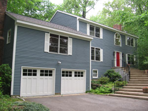
230 Old Kings Highway North, Darien, Connecticut. March 2006. |
In 1989, Peter and Marilyn Carroll Biggins and family purchased a house newly-built by St. John Associates on an acre of land in Darien, Connecticut, at 230 Old Kings Highway North, on the site of the the Red Mill at Five Mile River.
Next door, on the other side of the mill run, at 222 Old Kings Highway North, is a house built in 1880, when the Red Mill was still standing.
The Kings Highway
The street was originally part of the old Boston Post Road between New York and Boston, which was in turn part of the 1,300-mile Kings Highway ordered by Charles II, King of England from 1660 to 1685, to connect Boston with what is now Charleston, South Carolina. It was called the Country Road in Colonial times. Darien was called Middlesex and was part of Stamford, until 1820. The street name is provided in the U.S. Census starting in 1900: Farm Road in 1900, Old Post Road in 1910, Old Kings Highway in 1920, and Old Kings Highway North in 1930, 1940, and 1950.
Old Kings Highway now crisscrosses three newer and straighter routes:
The Railroad did not build a bridge; thus, today's Old Kings Highway North and South.
A 1789 atlas by Christopher Colles shows the Red Mill on the Old Post Road in Middlesex. A mile marker on the atlas indicates that the Red Mill is 48 miles from Federal Hall on Wall Street in New York City.
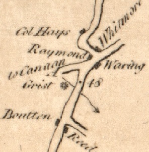
Excerpt from 1789 Colles atlas, Map 4, page 7, showing the Old Post Road, now Old Kings Highway North, the Red Mill ( Grist *), the Five Mile River (southbound squiggly arrow), and 48 miles from Federal Hall. Boutton is Nathan Bouton, owner of the mill from 1785 to 1804. Present day streets: Richards Avenue to the north (A to Canaan) and Rowayton Avenue and Raymond Street to the south. Source: 1789 Colles Map, Map 4. |
|
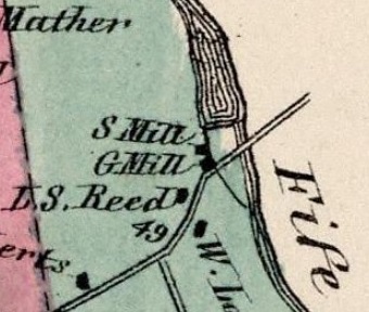
Excerpt from 1867 map showing- saw mill,
- grist mill,
- mill pond, and
- mill run.
Source: 1867 Darien map |
|
|
The Red Mill
As mentioned at the outset, in 1989, Peter and Marilyn Carroll Biggins and family moved into a newly-built house in Darien, Connecticut, at 230 Old Kings Highway North. The house backs up on the right bank of the Five Mile River. On the side of the house is the left bank of the mill run. This was the first house ever built on this site. The only previous structures were a gristmill (the Red Mill) and sawmill on the west side of the mill run between 1692 and 1908. The house on the east side of the old mill run. Remnants of the mill are still there.
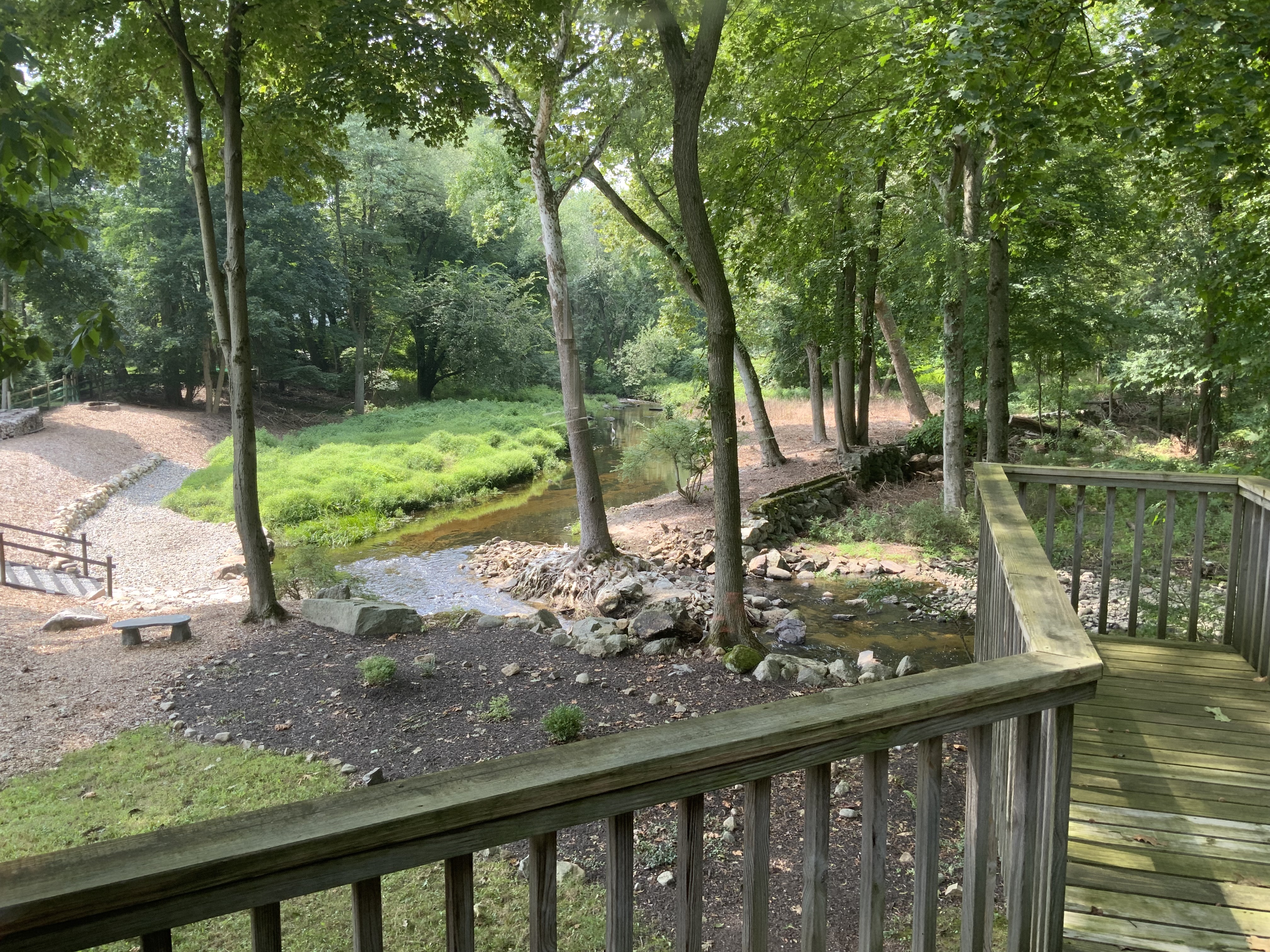
Remains of the dam after the leaves have fallen in November 2016 from the deck in the rear of out house at 230 Old Kings Highway North. |
|

Close up of the remains of the dam. |
|
- The dam across the river is gone. They say it was blown up in the 1920s. But there is still a long stretch of the dam that can be seen on the other side of the river.
- The mill pond has no water because the river is no longer dammed up, but outline of the mill pond can still be seen.
- The mill run has no water in it, but the long straight ditch from the mill pond to the river downstream can still be seen. The portion on the other side ofthe road was filled in when a new bridge was built in 1994.
- What appears to be a short stretch of the mill foundation can be seen not far from the road on the west side of the mill run. It is about 12 feet long and two feet high and is perpendicular to the mill run.
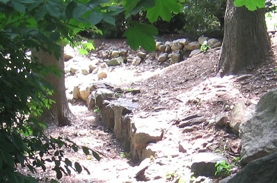
What appears to be a short stretch of the mill foundation can be seen not far from the road on the west side of the mill run. It is about 12 feet long and two feet high and is perpendicular to the mill run. |
|
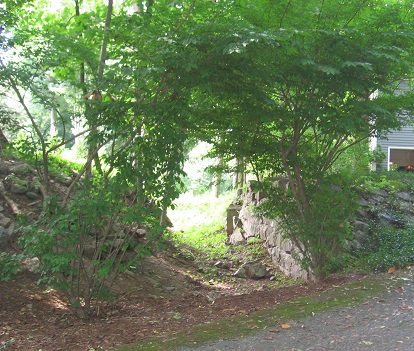
The mill run has no water in it, but the long straight ditch from the mill pond to the river downstream can still be seen. |
|
1867 Map
The location of the mills can be seen on the 1867 map of Darien.
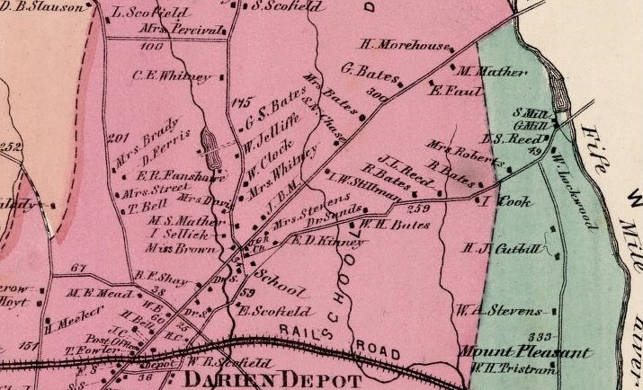
1867 map showing the grist and saw mills on the Five Mile River. The mills are at the point where the Country Road crosses the Five Mile River. The mill pond is north of the mills. The mill run reenters the river south of the road. The road parallel to the Country Road to the north is the newer Post Road. The road running south from the Country Road is Raymond Street. Published in 1867 by Beers Ellis & Soule. From David Rumsey Map Collection |
1984 Article
The Darien News-Review published an article on December 27, 1984, entitled "Tests may unveil secrets of old Red Mill."
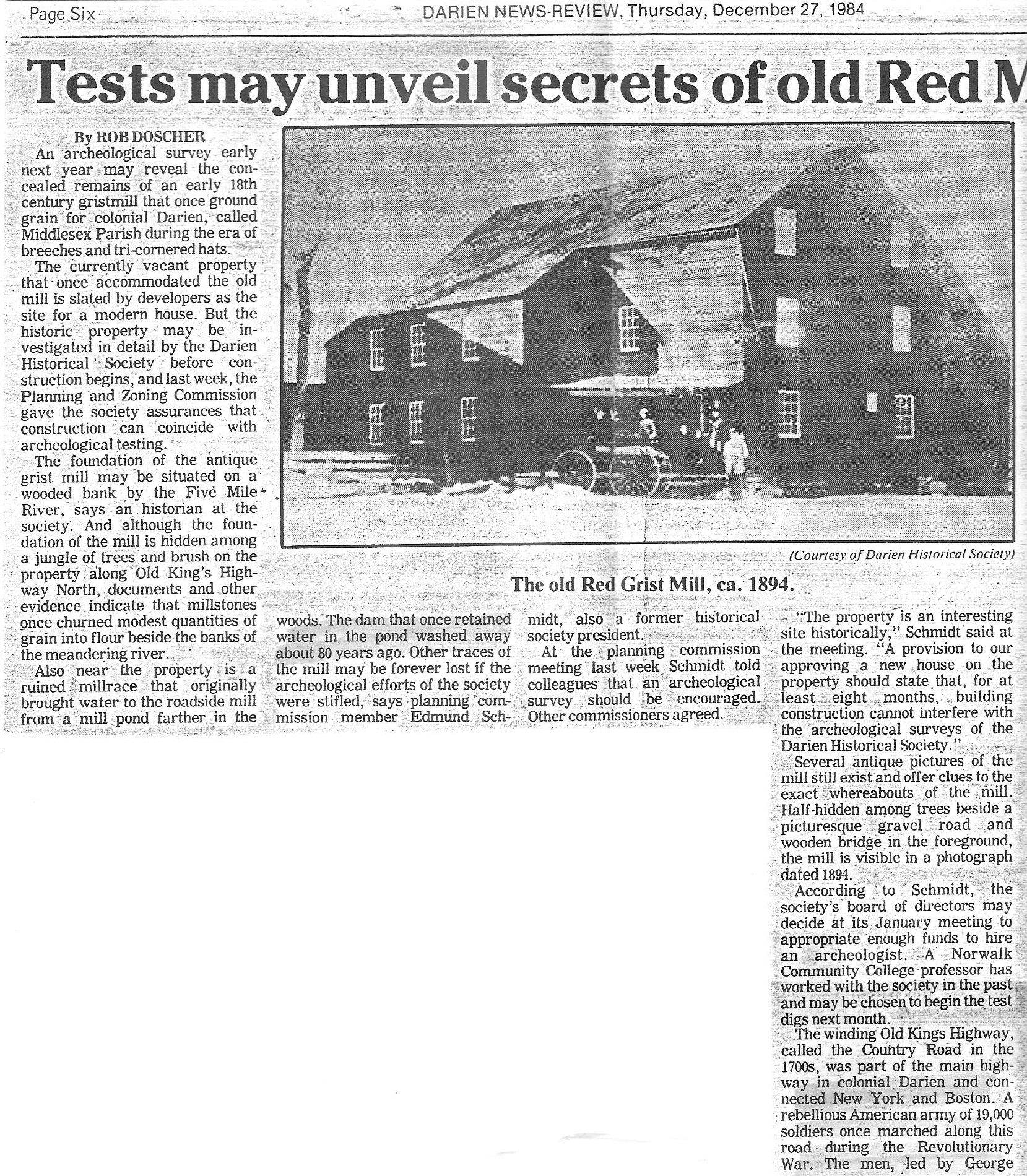
Darien News-Review, December 27, 1984. |
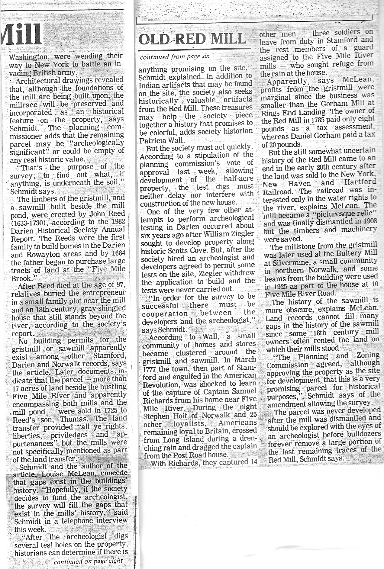
Darien News-Review, December 27, 1984. |
1982 Article

"The Red Mill at Five Mile River" by Louise H. McLean appears in Volume 4, Number 8, of the The Darien Historical Society Annual for 1982. Click on ther image to see the article. |
In 1982, Louise H. McLean (1906-2004), past president of the Darien Historical Society, wrote an article on "The Red Mill at Five Mile River" that appears in Volume 4, Number 8, of the The Darien Historical Society Annual.
Following is a timeline based in large part on the 1982 Historical Society article by Louise McLean.
| 1640 | The New Haven Colony bought from the Siwanoy Indians a tract of wilderness where the Rippowam River met the waters of Long Island Sound. The Siwanoys lived in small villages of bark-covered wigwams, and spent their lives fishing, hunting, and tending their cornfields. The eastern boundary of the purchase was the Goodwives River (then called Pine Brook) |
| 1644 | The boundary of Stamford was extended from Goodwives River to the Five Mile River with a purchase from the Roaton Indians |
| 1660 | John Reed (1633-1730), a Puritan, fled England when the monarchy was restored under Charles II |
| 1684 | John Reed began to purchase large tracts of wild land at "Five Mile Brook" on the Norwalk side of the stream. |
| 1692 | John Reed and his son John Jr. applied to the town of Norwalk for a permit "to erect a sawmill at the head of the salt" on the Five Mile River |
| 1699 | John Reed, age 65 and owner of 1/4 of the mill, transferred his share to his son Thomas and daughter Mary Tuttle |
| 1725 | The mill site and 17 acres of land were sold to John Reed's son Thomas |
| 1730 | John Reed Sr died and was buried on his property at what is now 525 Flax Hill Road |
| 1737 | The area now known as Darien became Middlsesex Parish, still part of Stamford. |
| 1753 | The estate of Capt. Jonathan Bates lists a sawmill appraised at 11.5 pounds |
| 1756 | Colonel George Washington of the Virginia Regiment, age 23, passed the mill as he traveled to Boston to discuss issues related to his rank with Governor William Shirley of Massachusetts. |
| 1758 | The inventory of Eleazar Green lists a sawmill appraised at 11.5 pounds |
| 1767 | Samuel Richards (1746-1785) bought the farm and gristmill from the Reeds |
| 1776 | General George Washington, passed by the mill in April on his way back from the Siege of Boston |
| 1772 | A stagecoach began providing service on the Country Road between New York and Boston every two weeks |
| 1777 | Tories from Long Island kidnapped Capt. Richards, father of the mill owner, and 14 other men. They were carried to Long Island by boat and thence to prison in New York City. After four months, Capt. Richards, a very sick man, was released, only to die soon after his return to Norwalk |
| 1785 | Samuel Richards sold his house, the gristmill, and much of his land for 400 pounds to his neighbor David Reed, who soon sold it to Nathan Bouton for 450 pounds |
| 1789 | Christopher Colles created his atlas of the Country Road, perhaps in time for use by President George Washington. The atlas has markers showing the miles from Federal Hall on Wall Street in New York City. The Noroton (then Roton) River was 44 miles. The Five Mile River was 48 miles |
| 1789 | President George Washington, age 57, passed by the mill on his tour surveying damage from the Revolutionary War in Norwalk and Fairfield |
| 1804 | Noyes Richards, son of Samuel, paid $3,150 for Nathan Bouton's 47 acres, house, barn, miller's house, and gristmill. Noyes had recently married Sally Mather, a granddaughter of Rev. Moses Mather |
| 1804 | Noyes Richards sold 2/3rds of the mill to Nathaniel Hoyt (1748-1822) of Hoyt Street |
| 1806 | The new straighter Post Road was completed, as an alternative to the Country Road, on which the mill was situated, replacing it as the main road through Middlesex Parish. |
| 1810 | The land on which the sawmill stood was purchased by Ralph Hoyt, the son of Nathaniel Hoyt |
| 1820 | Middlesex Parish, part of Stamford, became the separate Town of Darien |
| 1822 | John Reed Jr. became the owner of the mill after the death of Nathaniel Hoyt |
| 1825 | Zalmon Sturges bought the mill from John Reed Jr. |
| 1832 | Peter Leinberger (Linesburg) of New York City bought the mill from Zalmon Sturges |
| 1835 | Upon the death of Ralph Hoyt, his sister, Martha Hoyt Reed and her husband John Reed sold the sawmill to Henry Bates (1779-1840), son of Jonathan 3rd. The Reeds retained title to the land and miller's house |
| 1843 | A "spring freshet" washed out the dam |
| 1848 | The New Haven Railroad came through Darien, crossing the Country Road |
| 1855 | Nathan Roberts paid Peter Leinberger $1,000 for the mill and Leinberger's house at the corner of Raymond Street. |
| 1860 | G. W. Walker, 54, and son William, 25, are shown as millers in the U.S. Census for Darien (Norwalk Post Office), living three households away from Nathan Roberts |
| 1880 | George T. Miller, 37, and Newton Crofut, 37, are shown as millers in the U.S. Census for Darien, living in households next to each other, three households away from Sally Roberts. Sally is living with her son George, a lumber inspector, and her sister Esther Weed |
| 1894 | Photo shows the mill half-hidden among trees with a picturesque gravel road and wooden bridge in the foreground |
| 1900 | The mill was sold to the New York, New Haven, and Hartford Railroad |
| 1908 | Alexander Raymond dismantled the mill and stored the mill wheel and sold it to the Buttery Mill in Silvermine |
| 1925 | Harry Street, grandson of Alexander Raymond, used some of the beams from the mill in building his house at 10 Five Mile River Road |
| 1955 | I-95 came through Darien, crossing the Country Road, by then called Old Kings Highway South, at Corbin Road |
| 1982 | Louise H. McLean (1906-2004), past president of the Darien Historical Society, wrote an article on "The Red Mill at Five Mile River" that appears in Volume 4, Number 8, of the The Darien Historical Society Annual |
| 1989 | Peter and Marilyn Carroll Biggins and family moved into a newly-built house on the east side of the old mill run |
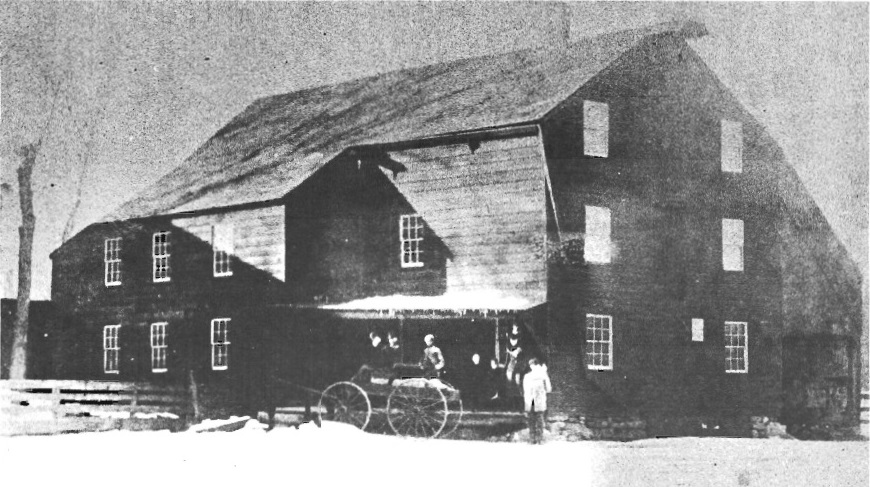
Picture from the old Post Road of the grist mill in wintertime. Part of the stone foundation at the front of the building is still standing. The mill run and undershot wheel were under the lean-to to the far right. |
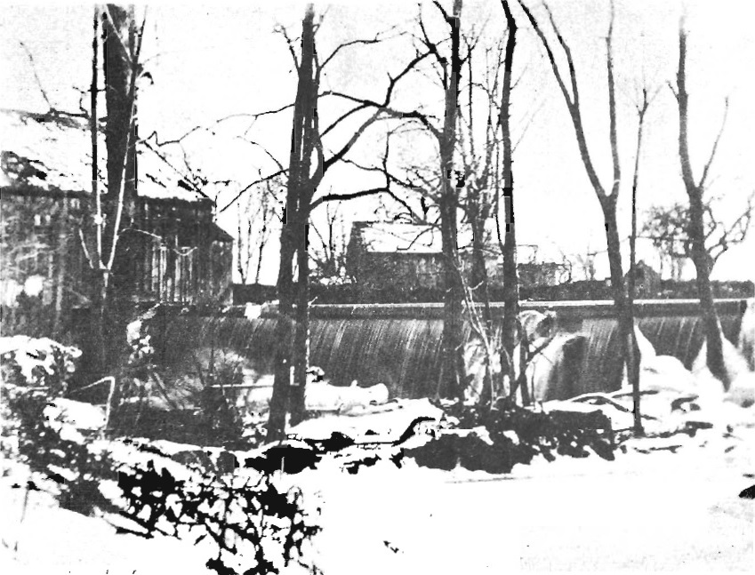
Picture from the Norwalk side of the Five Mile River. The saw mill is at the left. The river flowing over the dam in wintertime. Part of the dam out of the picture to the right is still standing. In the background are several buildings. One may be the miller's house. |
Captain John Reed (1633-1730)
John Reed, who built the Red Mill, was born in 1633 in Cornwall, England. He entered the army of the Commonwealth at the age of sixteen in 1649, rose to to the level of Captain, and gained distinction for some heroic
service. At the restoration
of Charles II in 1660, he left England with many others and came to America.
He was descended from a large family of Reeds in Dorsetshire. An ancestor, Col. John
Reed, was one who held the Castle of Poole against the
King's troops in 1649.
In 1660, John Reed emigrated to Providence, Rhode Island. In 1667, he
married a widow, Mrs. Anne Samson Derby, who became the mother of his children. After her decease
he married Mrs. Scofield. He moved to Rye, New York, in 1684, where he lived for three or four years. He moved to Norwalk, Connecticut, bought a large tract of land that became known as Reed's Farms, and made his home on the north side of Old Post Road on the Norwalk side of the Five Mile River. In 1692, he built the Red Mill on the Five Mile River. After the death of his wife, Ann, he married Mrs. Scofield in Stamford, Connecticut.
John Reed died in 1730. He was buried in his own
field without a headstone. In 1886, some of his
decendants set up a headstone. Following is a letter to Dwight Reed from Newton Reed, both great great great great grandsons of John Reed.
Five Mile
River, Conn.
Sept. 4, 1886
Dr. Dwight Reed:
Dear Doctor:—I am here a few rods from the old homestead and the old grave. I find the boulder just as it was
fifty years ago.
I shall have a suitable stone, Quincy granite, on the
place next Monday. The cost will not exceed the sum
promised, viz: one hundred dollars.
The inscription on the polished base of it is—
JOHN REED
Born in England
1633
Came to America
1660
Died 1730
Newton Reed |
|
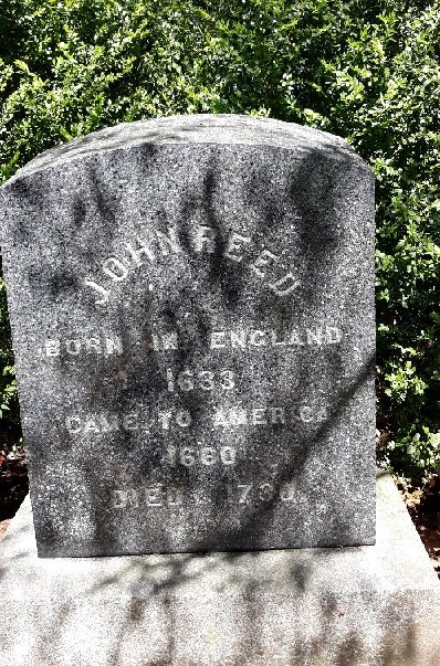
John Reed gravestone, 100 yards from the Five Mile River, on the western border of the far backyard of the house at 527 Flax Hill Road, Norwalk, CT.
Photo by Greg Smith, May 2021. The house was built in 1987. Prior to that the grave would have been said to be behind the house at 525 Flax Hill Road, which house was built in 1890. |
|
Sources:
- Find a Grave
- Reed-Read Lineage: Captain John Reed of Providence, R.I., and Norwalk, Conn., and His Descendants Through His Sons, John and Thomas, 1660-1909, by
Ella Frances Reed Wright,
The Mattatuck Press, Inc., Waterbury, Conn., 1909.
- "John Reed--1633-1730" by Charles E. Benton, The Connecticut Magazine: An Illustrated Monthly, Volume 6, Number 1, January 1900, page 17
|
 The Red Mill
 The Red Mill