Gold Mine at Mathenias CreekGold Mine at Mathenias Creek
Brother Thomas Smith, O.F.M., Carol Voss, Richard Drueke, and Betty and Gerhard Becker contributed to this story.
Index Family History Home Page
|
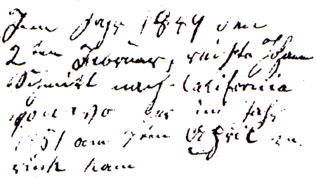
Bavaria. John Schmitt was born on September 19, 1820, in Kassel. At that time, Kassel was in the Main-Kreis region in the far northwest corner of the Kingdom of Bavaria. Kassel is small village and is now part of the town of Biebergemund. Tiffin, Ohio. John Schmitt immigrated to Tiffin, Ohio, in 1838. In 1842, Charles Dickens took a tour of the United States as far west as St. Louis, including a two-hour stopover in Tiffin on the way back. He was only 30 years old but already written five famous novels: The Pickwick Papers, Oliver Twist, Nicholas Nickleby, The Old Curiosity Shop, Barnaby Rudge. He brought his wife Kate, her maid, and his Bostonian secretary George W. Putnam. They arrrived in Tiffin at noon for lunch at a hotel. After they dined, they were driven triumphantly all about town on the way to the railroad station. At 2:00 p.m., they boarded a train on the Mad River and Lake Erie Railroad and traveled the 37 miles from Tiffin to Sandusky. John Schmitt married Mary Augusta Schickell, also a Bavarian immigrant living in Tiffin, in September 1847. They continued to live in Tiffin following their marriage. Their first child was born in Tiffin after John went to California for the Gold Rush in February 1849. The July 1850 U.S. Census for Tiffin, shows Mary A. Smith, 20, born in Germany, and a Mary A, Smith, 1, born in Ohio. They are living with Catherine Smith, 60, born in Germany. There is no John Smith listed, presumably because he was in California. There is also a Catherine Smith, 60, probably John's mother. Mathenias Creek, California. One day I was looking at a page for special events from the bible of my great great grandfather, John Schmitt, that my cousin Richard Drueke had given us. It was written in German script, but the word "California" popped out. Then I saw what looked like a date in 1849. Gerhard and Betty Becker deciphered the German script:
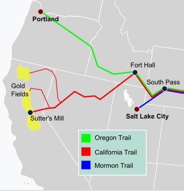
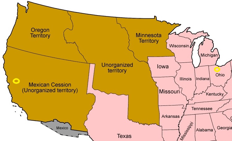
It looks like John was a "49er." Then I found John in the October 1850 Census for Mathenias Creek, working as a miner. "Eureka!" He was living on Mathenias Creek in El Dorado County, California. He was on the 11th of 16 pages for "on Mathenias Creek" in the 1850 census. Each page has 42 persons. That's a total of 672 people living on the creek. Of these, 627, or 93%, were gold miners. The remaining 7% consisted of 18 family members, 11 merchants, 5 laborers, 3 physicians, 1 butcher, 1 stock trader, 1 farmer, 1 express carrier, and 4 whose occupation could not be deciphered. Mathenias Creek is now called Martinez Creek. It is seven miles long. We do not know exactly where John lived on the Creek. It is not certain that the John Smith on Mathenias Creek was our John Smith. Our John Smith would have been 29 or 30 instead of 28, but census ages are not always reliable. There also was a John Smith from Germany in the census for Township No. 5 in Tuolumne County, but he was a year younger than the one on Mathenias Creek. And, there were eight other John Smiths of a similar age born in Germany. Four had middle initials, which our John did not use. Some were not miners. But, next to John on Mathenias Creek were two miners named Cordes: John and William. Because of future relationships between their families, as outlined below, their presence next to John in the census lends credence to the John of Mathenias Creek being our John. Their ages were 28 and 18. They were likely the sons of Anton Cordes (1790-1846) and Elizabeth Platte Cordes (1792-1876), who were immigrants from Prussia living in Alpine Michigan and had sons that age who were not living with them in the 1850 census. In the Mathenias Creek census, they are shown as from "Pa." Perhaps they said they were born in "Prussia," but the census taker thought they said "Pennsylvania." Perhaps the census taker abbriviated Prussia as "Pa." The Mathenias Creek is in the Sierra Nevada mountain range, west of the The El Dorado National Forest. It is 13 miles south southeast of Sutter's Mill. It is just south of Diamond Springs. Diamond Springs is 46 miles east of Sacramento, which is in the Central Valley of California. Mathenias Creek was in the past also called Mathinias, Mathenas, and Matheneys Creek. None of these names can be found on present-day maps. The name is now Martinez Creek. Treaty of Guadalupe Hidalgo. The United States acquired California and other southwest territories from Mexico on February 2, 1848, in the Treaty of Guadalupe Hidalgo, which followed the Mexican-American War of 1846-48, also known as the War of North American Invasion. See: Treaty of Guadalupe Hidalgo. John Smith left for California on February 2, 1849, the first anniversary of the Treaty of Guadalupe Hidalgo. California did not become a State until September 9, 1850. California Trail. It is estimated that approximately 90,000 people went to California in 1849—about half by land and half by sea. Of these, perhaps 50,000 to 60,000 were Americans. The California Trail was an emigrant trail of about 1,600 miles across the western half of the North American continent from Missouri River towns to California. After it was established, the first half of the California Trail followed the same corridor of networked river valley trails as the Oregon Trail and the Mormon Trail, namely the valleys of the Platte, North Platte, and Sweetwater rivers to Wyoming. The main route of the California Trail branched from the Oregon Trail west of Fort Hall, as immigrants went on forward going southwestward into present-day Nevada, then down along the Humboldt River to the Sierra Nevada.
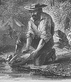
Gold Rush. On January 24, 1848, gold was discovered at Sutter's Mill in Coloma, California. Word of the Gold Rush spread slowly at first. In March 1848, San Francisco newspaper publisher and merchant Samuel Brannan, after he had hurriedly set up a store to sell gold prospecting supplies, strode through the streets of San Francisco, holding aloft a vial of gold, shouting "Gold! Gold! Gold from the American River!" On August 19, 1848, the New York Herald was the first major newspaper on the East Coast to report that there was a gold rush in California. On December 5, 1848, the State of the Union message of President James Knox Polk urged Americans to explore and exploit California's new-found mineral wealth. Suddenly a mania for gold swept the United States. See: California Gold Rush. See also: Mindat.
El Dorado County. The County of El Dorado was one of California's original counties created effective February 18, 1850. Its name is derived from the Spanish meaning "the gilded/golden." It is located entirely in the Sierra Nevada, from the historic Gold Country in the western foothills to the High Sierra in the east. The Mother Lode starts just south of the northen border, which is the Middle Fork of the American River. The Mother Lode contunues south across the South Fork of the Cosumnes River, which is the southern border of El Dorado County. Source: El Dorado County, California. Mines of El Dorado County. The Mother Lode of El Dorado County is on the east side of State Road 49, also known as the Golden Chain Highway at the request of the Mother Lode Highway Association. See: State Road 49. Doug Noble lists about 500 mines in El Dorado County, but only four mines date back to the 1850s. The only mine with the name Mathenias, Mathenas, or Martinez is the the Mathenas Creek (Schneider) Mine that was active between 1888 and 1894. He says that during the discovery of gold around 1850, thousands of mineral claims were filed. "Each mining claim was named by the miner or miners who discovered or worked it. Like the towns they created, some reflected their personal name, the place they had left from on their trip west, loved ones left behind, a nearby physical landmark or often, something now totally obscure. In time some of these claims grew into large mining operations operated by a cooperative "company" or large crews of hired miners. However, most were simply abandoned, once any value was removed, and soon became just a forgotten entry in the record books. Like the early towns and roads, these mines, and often their names, have become a part of our history." Source: Mines of El Dorado County by Doug Noble, copyright 2002. See also: 1902 Register of Mines and Minerals for El Dorado County Mile Markers for Martinez Creek. Following are rough approximations of locations on Martinez Creek in El Durado County.
Where on Martinez Creek?. Martinez Creek has been known in the past as Mathenias Creek, Mathinias Creek, Mathenas Creek, and Matheneys Creek. John Smith was living on Mathenias Creek in El Dorado County, California, in the October 1850 Census. We do not know specifically where John was working on the 7 miles of the Creek. There were 16 pages for Mathenias Creek in the 1850 census, each with 42 persons. That's a total of 672 people living on the creek. Of these, 627, or 93%, were gold miners. They could not all be working in the same place on the creek. If they were spread out evenly over the seven miles of the creek, that would make 90 miners per mile.
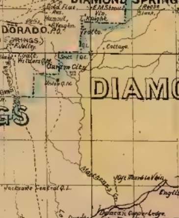
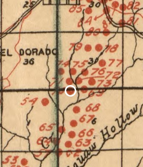
A 2002 booklet by Doug Noble, Mines of El Dorado County, says the Mathenas Creek (Schneider) mine was one mile south of Diamond Springs. An 1883 History of El Dorado County by Paolo Sioli states that in 1855, the town of El Dorado, which is two miles south of Diamond Springs, was incorporated and included what was then known as Empire Ravine, Dead Man's Hollow, Loafer's Hollow, Logtown creek, Matheney's creek, Slate and Dry creeks. With help from the California State Library and the Map Room of the New York Public Library, I was able to locate the mine on a 1909 map of El Dorado County issued by the California State Mining Bureau and Lewis E. Aubrey, State Minerologist. It shows mines with dots and numbers. A Register issued with the map shows that the Mathenas mine is No. 70 on the map, putting it on a tributary of Martinez Creek. Using the 1909 map, it is possible to plot the mine on a present-day map. The Register has separate tables for different kinds of gold mines. The table for Quartz Mines, by far the largest, contains information about the Mathenas mine. From 1902 Register of Mines and Minerals for El Dorado County:
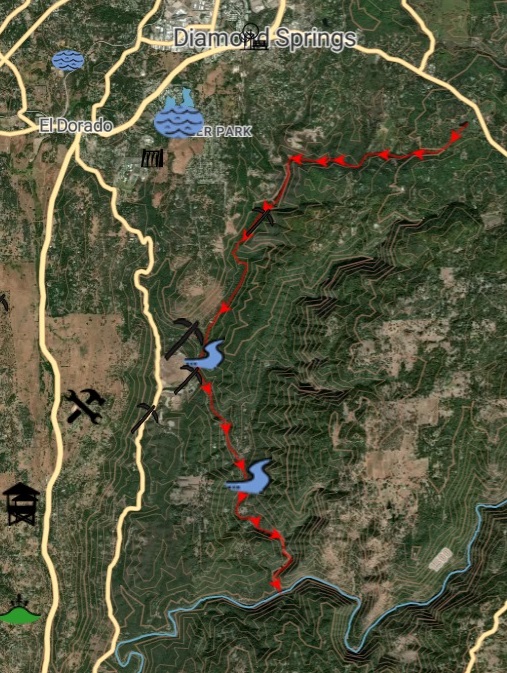
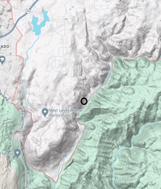
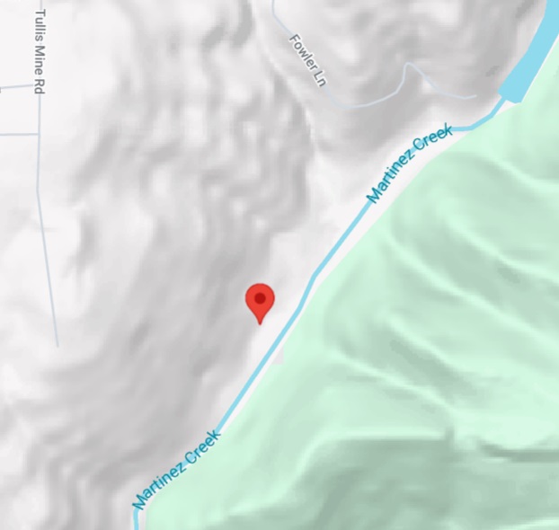
Note: The 1900 U.S. census for Diamond Springs shows a John Koch, 39, single, hotel keeper, born in Califonia, parents born in Germany. David Cismowski, Senior Librarian, California State Library, provided these Annual reports of the California State Mineralogist that mention the Mathenas Creek mine in 1888, 1890, 1894, 1896, 1916, 1926, and 1938. Mine No. 70 on 1909 Map. Using the 1909 map, it is possible to approximate the position of the mine on a present-day map. The white circle on the map on the left shows the Mathenias Creek gold mine, No. 70 on the 1909 map of El Dorado County. The black circle on the Google map on the right shows a corresponding location of the Mathenias Creek gold mine, on Martinez Creek, 0.2 miles east of the end of Tullis Mine Road, at latitude 38.668983 and longitude -120.817091.
Directions from Sacramento to the end of Tullis Mine Road, Diamond Springs are:
Tiffin, Ohio. John and Mary Augusta's first child, Mary Appolonia Schmitt, was born in Tiffin on August 10, 1849, six months after her father left for California. She eventually went by the name Abbie Smith. On April 7, 1851, John Smith returned to Tiffin, Ohio, from the California. His gold mining days were over. He was away for over two years. There is no indication that he made a fortune there. Grand Rapids, Michigan. Less than a year after John returned to Ohio, the Schmitts moved from Tiffin to Grand Rapids, Michigan, close to where the Cordes family lived in Alpine, Michigan. He had lived next to their two sons on Mathenias Creek. John and Mary Augusta's second child, Crescenz Joseph Schmitt, was born in 1852. He became a musician and eventually went by the name Cris J. Smith. John and Mary Augusta's third child, Rosa Wilhelmina Schmitt, was born in Grand Rapids on October 6, 1854. In the 1856 and 1859 business directories, John Smith was listed as a saloonkeeper. In 1856 the address of the saloon was given as Front Street. In the 1860 census, the family was living in the 4th Ward of Grand Rapids, and John was listed as a saloonkeeper. John Schmitt died in Grand Rapids on March 17, 1861. He was buried in St. Andrew's Cemetery. He was 40 years old. He left his wife Mary Augusta and three young children. John and Mary Augusta's second child, Crescenz Joseph Schmitt is my great grandfather. In 1880, at age 28, he married my great grandmother Christine Koch, 19, in Grand Rapids. In 1882, Cris and Christine had a daughter, Rose Viola, my grandmother. Christine died in 1887, when daughter Rose Viola was five years old. John and Mary Augusta's third child, Rosa Wilhelmina Schmitt married Charles Andrew Hauser in 1882 and raised my grandmother Rosa Viola after her mother Christine died in 1887. My grandmother called Rosa Wilhelmina "Tante." John and William Cordes. As mentioned above, also mining gold on Mathenias Creek in El Dorado County were John and William Cordes. The 1850 U.S. Census for Mathenias Creek lists them right above John Smith. Their ages were 28 and 18. They were likely the sons of Anton Cordes (1790-1846) and Elizabeth Platte Cordes (1792-1876), who lived in Michigan and had sons that age named John and William. The Cordes family had immigrated from Helden, Germany, and settled in Westphalia, Michigan, in 1836. In 1844, they moved to Alpine, a farming commmunity just north of Grand Rapids. Alpine was in Saint Mary's, a German parish created in 1857 on the west side of the Grand River. John and Mary Augusta Smith moved here in 1851 from Tiffin. There are a number of connections between six Cordes brothers, the Smith family, the Schickell family, and the Berles family. My grandmother descends from the Smith and Schickell families. My grandfather descends from the Berles family. His father immigrated from Helden in 1871.
There were three other siblings:
| ||||||||||||||||||||||||||||