Some Illinois History
| 1673 | French explorers Jacques Marquette and Louis Jolliet paddled up the Mississippi, Illinois, and DesPlaines Rivers, passing within two miles of what would become the Biggins Farm. Around what is today 55th Street and Harlem Avenue, they portaged a couple miles to the Chicago River and Lake Michigan. They claimed the upper Midwest for King Louis XIV as part of New France |
| 1717 | Illinois became part of the French colony of Louisiana |
| 1763 | Illinois became part of the British Empire as a result of the Treaty of Paris ending the Seven Years' War (known as the French and Indian War in the United States) |
| 1783 | Britain ceded Illinois to the United States as part of the Treaty of Paris ending the Revolutionary War. (Connecticut claimed the northern portion of Illinois, corresponding to Connecticut's latitude, until 1786) |
| 1786 | Connecticut ceded its claim to the northern portion of Illinois, corresponding to Connecticut's latitude (41st and 42nd parallels north), which includes Chicago and Lockport |
| 1787 | The Northwest Ordinance placed Illinois in the Northwest Territory |
| 1789 | Constitution became effective and George Washington took the oath of office at Federal Hall in New York City |
| 1799 | George Washington died at home in Mount Vernon, Virginia |
| 1800 | Illinois became a part of the Indiana Territory. Capital was Vincennes |
| 1807 | Patrick Beggan was born, most likely in Drumgill, County Cavan, Ireland |
| 1809 | Illinois became a Territory (included Wisconsin and northern Minnesota) |
| 1816 | The U.S. Congress decided to construct a 97-mile canal to facilitate greater non-Indian settlement in Illinois. The canal would connect the Chicago River at what is now called Bridgeport in Chicago with the Illinois River at LaSalle, allowing travel from New York City through the Hudson River, the Erie Canal, and the Great Lakes to the Illinois and Mississippi Rivers and New Orleans |
| 1818 | Illinois became the 21st U.S. state |
| 1827 | U.S. Congress gave the Illinois & Michigan Canal odd-numbered sections of land five miles on either side of proposed Canal |
| 1833 | Patrick and Bridget Biggins' second child Anna was born in Upper Canada (Ontario) |
| 1833 | Chicago became a town |
| 1834 | The eastern third of Illinois was taken from the Diocese of Quebec and made part of the new Diocese of Vincennes, Indiana, by Pope Gregory XVI |
| 1835-38 | Patrick and Bridget Biggins immigrated from Upper Canada (Ontario), to the United States. They settled in what became Lockport, DuPage Township, Will County, Illinois |
| 1836 | Commissioners of the Illinois & Michigan Canal selected Lockport as headquarters for the canal and site of Lock No. 1 |
| 1836 | Will County created |
| 1836 | Construction began on the Illinois & Michigan Canal |
| 1837 | Chicago became a city |
| 1838 | St. Patrick's Church established in Joliet. Father John Francis Plunkett was made pastor by Bishop Simon Bruté of the Diocese of Vincennes. Father Plunkett was born in Dublin in 1798 |
| 1838-46 | Patrick and Bridget Biggins' last five children were born |
| 1843 | Northeastern Illinois was taken from the Diocese of Vincennes and made part of the new Diocese of Chicago by Pope Gregory XVI |
| 1846 | St. Dennis Church established in Lockport |
| 1848 | Opening of the Illinois & Michigan Canal. Canal boats pulled by horses and mules on a towpath |
| 1848 | Patrick Biggins purchased 160 acres in Section 33 of DuPage Township, on the south side of Normantown Road, from the Illinois & Michigan Canal Commission for $640 |
| 1849 | DuPage Township created |
| 1857 | Chicago & Alton Railroad built alongside the Illinois & Michigan Canal |
| 1860 | Patrick Biggins became a naturalized citizen of the United States, renouncing allegiance to Victoria, Queen of Great Britain and Ireland since 1837. |
| 1861 | Abraham Lincoln became president of the United States. The Civil War started |
| 1865 | The Civil War ended. Abraham Lincoln was assassinated. The funeral train traveled 1,654 miles through seven states. At 11 pm on Tuesday, May 2, the train passed two and a half miles east of the Biggins Farm on the Chicago & Alton Railroad. |
| 1866 | Patrick Biggins purchased 160 acres on the north side of Normantown Road, kitty-corner from the original 160 acres, for $6,500 |
| 1874 | Patrick sold the western half of the 1866 purchase to his son James and the eastern half to his daughter Catherine |
| 1880 | The 1880 census shows James and Catherin living in separate households--James with his wife and two children and Catherine with her father Patrick |
| 1882 | Patrick Biggins died at age 75. The Will County Commercial Advertiser reported the day after that “consumption, that relentless destroyer of man, was the disease that sought and finally carried him to his long home.” Funeral rites at St. Dennis Church included a Solemn High Mass |
| 1895 | Romeoville became a village |
|
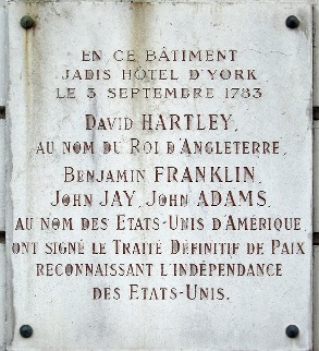
Commemorative plaque at the place where the Treaty of Paris was signed at 56 rue Jacob, Paris 6. Britain ceded Illinois to the United States as part of the Treaty of Paris ending the Revolutionary War. (Connecticut claimed the northern portion of Illinois, corresponding to Connecticut's latitude, until 1786). Source: Treaty of Paris (1783).
|
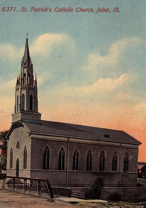
St. Patrick's Church, Joliet, Broadway Street, 1838-1917. Where Patrick and Bridget's last five children were baptized..
|
|
|
2004 Trip to Chicago
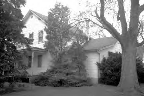
In June 2004, Marilyn and I took a trip to Chicago and went to Romeoville, in DuPage Township, where my great great grandparents, Patrick and Bridget Biggins, had lived on a farm in the 1800s. We saw an abandoned farm house on the property on Normantown Road. I took a photo, but had no idea whether whether my ancestors had ever lived there. We thought nothing more of it until, thirteen years later, I stumbled upon a 2001 historic preservation report that included a photo and short write-up on the Biggins farmstead. It took me a couple weeks to remember that we had seen a farm in 2004 and had taken a photo. I found my photo and compared it with one in the 2001 report. They were the same.
|
|
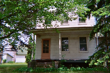
House on Normantown Road on farm purchased by Patrick Biggins in 1866. Source: 2004 photo by Peter Biggins.
|
|
It was probably Patrick's son James A, Biggin who built this house on Normantown Road. In 1874, he bought from Patrick the western 80 acres of Patrick's portion of Section 28. James married Elizabeth Healy in 1875. In the 1880 census, James and his family were living in a separate household (page 3) from his sister Catherine and her father Patrick (page 4)--probably James in the western half and Catherine in the eastern half.
Patrick and Bridget Biggins were born in Ireland and married sometime between 1825 and 1829. They were married in County Monaghan or Cavan, Ireland, where Patrick was from, or Ontario, Canada, where their second child is known to have been born.
Patrick and Bridget's first child was a girl, born sometime between 1826 to 1830, based on the 1840 census, which included only the name the head of the household. This is all we know of their first child. She has not been found in future censuses. Sometime before 1835, Patrick and Bridget immigrated to Canada. They settled somewhere Ontario. Sometime between 1835 and 1838, they immigrated to the United States. They settled in Lockport, DuPage Township, Will County, Illinois.
In 1816, two years before Illinois became a state, Congress decided to construct a 97-mile canal to facilitate greater non-Indian settlement in Illinois. The canal would connect the Chicago River at what is now called Bridgeport in Chicago with the Illinois River at LaSalle, allowing travel from New York City through the Hudson River, the Erie Canal, and the Great Lakes to the Illinois and Mississippi Rivers and New Orleans. The Federal government negotiated with the Potawatomi and other Indian tribes to sell their land to the Federal government and leave for lands west of Illinois.
Illinois land was surveyed and divided up into square townships, six miles by six miles. The townships in turn were divided into 36 square sections, one mile by one mile, which amounts to 640 acres. The sections could be further divided into 160-acre quadrants or half quadrant (80 acres) or quarter quadrants (40 acres). In 1827, the U.S. Congress gave the Canal Commission alternating sections of land five miles on either side of the Illinois and Michigan Canal to finance construction.
Lockport got its name and its start in 1836, when the Commissioners of the Illinois & Michigan Canal selected it as headquarters for the canal and site of Lock No. 1.
According to the History of the Village of Lemont, almost all the early Spioneers came to work on the canal, either as contract holders or laborers. The contractors were mostly from New England or the Ohio border towns. The unskilled laborers were the newly immigrated Irish, German, Scandinavians, along with French and English Canadians who came looking for a new life, fleeing poverty and political persecution. The Canal Corridor Association, the Irish began arriving in northern Illinois in large numbers in 1836, to work on the I&M Canal. A history of St. Dennis Church in Lockport (150 Years of Faith by Georgene McCanna Bankroff, 1996) says newspaper ads in Ireland offered good wages for canal workers, $26 a month, food, and lodging. Thousands of men were attracted by this offer during a depression caused by the Panic of 1837. Most Irishmen were uneducated farm workers who were looking to better their station in life.
The Illinois and Michigan Canal was constructed from 1836 to 1848. In 1838, there were 2,000 men employed on the Illinois and Michigan Canal. Patrick could have been employed by the canal as a laborer. The Census shows that he and Bridget could not read or write. Or, he could have been a supervisor or a supplier.
Patrick and Bridget had five of their seven children in Illinois, from 1838 to 1846, prior to completion of the Canal.
Sometime between 1840 and 1845, Patrick and Bridget moved from Lockport to DuPage Township. An 1845 report from school district No. 4 to DuPage Township shows P. Biggins with three children under age 20. These would be the girl born in Ontario, 15+, Ann, 10, and Frank, 7. This is the first evidence that Patrick and Bridget had moved from Lockport to DuPage Township. It is possible that they were farming the land that they later purchased in 1848 prior to the purchase.
The Canal Commission report to the Illinois State Legislature for the year ended November 30, 1848 indicates that a P. Beggins sold oats to the Commission for $9.97 on January 18, 1848.
The first canal boats came down the canal on April 19, 1848. Barges were powered by horses and mules on a towpath. Traffic increased until the mid-1850s when the Chicago & Alton Railroad was completed far enough to make shipping and travel by rail more attractive than barge.
On September 11, 1848, Patrick Biggins purchased 160 acres of land from the Illinois & Michigan Canal Commission for $640. The land was on the south side of Normantown Road in Romeoville, Illinois. The western 80 acres is now a subdivision called Lakewood Estates. The eastern 80 acres is now the Beverly Skoff Elementary School and the John J. Lukancic Middle School.
On June 23, 1866, Patrick purchased 160 acres on the north side of Normantown Road, kitty-corner from the original 160 acres, for $6,500. The Thos. J. Sprague farm, on which the Sprague school stood, abutted the east side of this plot. The western 80 acres was developed as Misty Ridge, a community of 166 homes, built from 2009 to 2016 by Beechen & Dill Builders, Inc. The eastern 80 acres was developed in 1963 as a residential subdivision, part of Hampton Park 2 West.
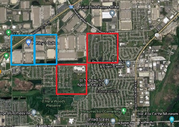
2021 Google Map of area in 1873 Map shown below. |
|
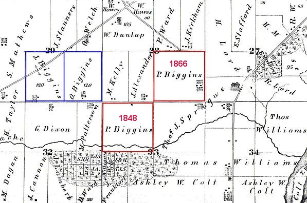
Six square-mile sections from the 1873 DuPage Township plat map. The Patrick Biggins land is outlined in red: the 1848 plot to the south, the 1866 plot to the north. The road running east-west between the two Patrick Biggins plots is Normantown Road. The road on the east side of the 1866 plot is now called Dalhart Road. The Sprague school is east of the 1866 plot on Joliet Road. The road running diagonally north of the 1866 Biggins plot is now Veterans Parkway. The James and Owen Biggins land is outlined in blue. The road running diagonally through the James Biggins land is now Interstate 55, which runs between Chicago and St. Louis. It is also called "Historic U.S. 66." Full Map.
|
|
|
1955 Aerial Photo
John W. Drury (1898-1973) published in 1955 This Is Will County. It was No. 26 in his American Aerial County History Series. The Biggins farm on page 95 is one of 176 in the DuPage Township section. The description under the photo is: "George Mather, Rte. 3, Lockport, 160 acres." George Mather owned the Biggins farm in 1955. Route 3 was Normantown Road. The book divides DuPage Township into five areas based on the nearest city or town: Joliet, Lemont, Lockport, Naperville, and Plainfield. The Lockport area of DuPage Township is the one nearest the city of Lockport and includes Normantown Road.
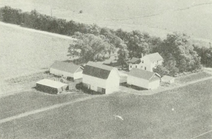
American Aerial County History Series, This Is Will County, No. 26, by John Drury, 1955. Aerial Survey of Biggins Farm on page 95: George Mather, Route 3, Lockport, 160 acres.
|
|
2001 Rural Historic Structural Survey
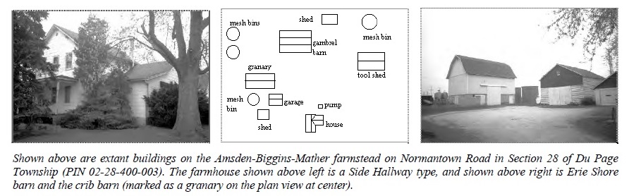
The Will County Historic Preservation Commission has undertaken a Rural Historic Structural Survey that includes DuPage Township (completed in 2001 by Wiss, Janney, Elstner Associates, Inc.). In Chapter II, pages 24-26, there is a section on Significant and Contributing Farmsteads in Du Page Township, starting with the photos and a buildings diagram of the "Amsden-Biggins-Mather farmstead" on Normantown Road.
Significant and Contributing Farmsteads in Du Page Township 59
Amsden–Biggins–Mather
"Albert Amsden is shown on the 1862 plat map as being the owner of the southeastern quarter section of
Section 28 in Du Page Township. The plat map also shows the farmstead fronting on contemporary
Naperville Road. The 1860 federal population census lists Albert Amsden, 36; his wife Sarah, 30; and three
children: Oscar (born in Michigan), 11; Ella (born in Illinois), 8; and Alice, 9 months. The Agricultural
Schedules of the 1860 federal census listed the A. Amsden farm as having 160 improved and 5 unimproved
acres. The estimated values of the farm and the farming implements were $4,125 and $200, respectively.
The farm had livestock valued at $600, which included 5 horses, 8 dairy cows, 5 cattle, and 12 swine. The
output of the farms for the preceding year was 150 bushels of wheat, 700 bushels of corn, 450 bushels of
oats, 10 bushels of peas and beans, 60 bushels of potatoes, 65 bushels of barley, 700 pounds of butter, and
40 tons of hay. (Albert Amsden was the census taker in Du Page Township in 1860.)
"The 1860 census also lists Patrick Biggins farm as being 160 acres. As shown on the 1862 plat map, Biggins
farm was located in the northwest quadrant of Section 33 in Du Page Township, land he had owned since
1848.60 The 1850 federal population census listed Patrick Biggins (spelled “Begins” on census forms), 40,
born in Ireland; Bridget, 45, also born in Ireland; sons Francis, 12; Philip, 9; and James, 4; and daughters
Ann, 15; Catherine, 10; and Rosanna, 7. Ten years later, the census does not include Bridget Biggins,
indicating that she had died.
"Between 1860 and 1870, Biggins purchased the Amsden farm (this is shown on the 1873 plat map). The
1870 census indicates the Biggins farm contained 320 improved acres. The estimated values of the farm
and the farming implements were $16,000 and $1,000 respectively. A total of $600 were paid in wages
for hired help including the cost of board. The farm had livestock valued at $1,900, which included 11
horses, 6 dairy cows, 28 cattle, and 10 swine. The output of the farms for the preceding year was 300
bushels of spring wheat, 1200 bushels of corn, 2500 bushels of oats, 110 bushels of potatoes, $3 worth of
orchard produce, 300 pounds of butter, and 60 tons of hay.
"Presumably after Patrick Biggin’s death the farm in Section 28 passed to his son James.61 This is the
farmstead that is present on Normantown Road today. As shown on the 1893 plat map, the farmstead
belonging to the James Biggins family occupied the west half of the southeastern quarter section in
Section 28. The eastern half of this quarter section is identified as belonging to Margaret Reardon (her
relationship to the Biggins family, if any, is not known).
"The 1909 plat maps show E. Biggins as the holder of the farmstead in Section 28 (Catherine Biggins,
discussed below, is listed as owning the land in Section 29). The Will County Farmers’ Directory of 1918
lists E.W. Biggins as a chicken farmer married to Mamie O’Connor with five children: William, James,
May, Catherine, and Margaret. His farm was 182 acres and he had lived in the county since 1870. H.R.
Phelps is listed as owner of the farmstead on the plat map from circa 1940. By the 1960s, this farmstead
had passed to members of the Mather family. George, Millie, and George L. Mather are listed in
succession on the plat maps between 1966 and 1998."
59Illinois Public Domain Land Tract Sales Database.
60This portion of the narrative describes the families who occupied significant extant farmstead sites in the threetownship
survey area. A few, although by no means all, of the families who had a significant impact on Will County
agriculture and whose farmstead sites have not survived are also described. Sources of information have included
the plat maps listed in the bibliography to this report as well as a variety of historical writings, including Will County
Property Owners (1842); George H. Woodruff, History of Will County Illinois (1878); Souvenir of Settlement and
Progress of Will County, Illinois: A Review (1884); Portrait and Biographical Album of Will County, Illinois (1890);
Genealogical and Biographical Record of Will County, Illinois (1900), W.W. Stevens, Past and Present of Will
County, Illinois (1907); August Maue, History of Will County, Illinois (1927); as well as federal census data and the
Agricultural Schedules from the 1850, 1860, 1870, and 1880 censuses.
61The James Biggins discussed here is not to be confused with the James Biggins discussed below. Based on the
research materials that were reviewed, it is not clear if the two were related. However, the farms comprising the
James Biggins Estate did pass to Catherine Biggins as of the 1909 plat map.
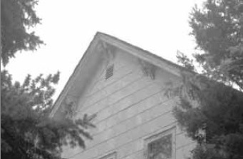
On page 62 of Chapter I, the survey says the "area has numerous examples of Italianate or
Italianate-influenced buildings." "Other houses have Italianate detailing,
such as shown above at the gable of the Biggins-Phelps-Mather
farmhouse on Normantown Road in Section 28 of Du Page
Township."
|
U. S. Agricultural Census
The Agricultural Census for Patrick's farm for 1850, 1860, and 1870 shows livestock (horses, milch cows, working oxen, other cattle, and swine) and farm production (wheat, Indian corn, oats, Irish potatoes, butter, and hay).
| | 1850 | 1860 | 1870 |
|---|
| Source |
Image 1 Image 2 |
Image 1 Image 2
|
Image 1 Image 2
|
| Name of Owner, Agent, or Manager of the Farm |
Patrick Biggins (Line 6) |
Patrick Biggins (Line 31) |
Patrick Biggins (Line 26) |
| Improved Acres of Land |
140 |
160 |
320 |
| Unimproved Acres of Land |
20 |
- |
- |
| Cash Value of Farm |
$1,500 |
$4,500 |
$16,000 |
| Value of Farming Implements and Machinery |
$50 |
$200 |
$1,000 |
| Livestock |
4 horses, 12 milch cows, 2 working oxen, 11 other cattle, 6 swine |
12 horses, 6 milch cows, 1 other cattle, 5 swine |
11 horses, 6 milch cows, 20 other cattle, 10 swine |
| Value of Livestock |
$440 |
$850 |
$1,900 |
| Annual Production (bushels) |
500 wheat, 300 Indian corn, 600 oats, 100 Irish potatoes |
100 wheat, 200 Indian corn, 800 oats, 20 Irish potatoes |
350 wheat, 1,000 Indian corn, 2,500 oats, 110 Irish potatoes |
| Annual Production (pounds) |
1,000 butter |
270 butter |
500 butter |
| Annual Production (tons) |
50 hay |
60 hay |
60 hay |
|
History of the Biggins Farm, 1827 to 2007
The table below shows transactions and listings from plat maps and other sources from 1827 to 2007 for the plots of land purchased by Patrick Biggins.
| Year
| Western 80 Acres of 1848 Plot
Western Half of Northwest Quadrant of Section 33 |
Eastern 80 Acres of 1848 Plot
Eastern Half of Northwest Quadrant of Section 33 |
Western 80 Acres of 1866 Plot
Western Half of Southeast Quadrant of Section 28 |
Eastern 80 Acres of 1866 Plot
Eastern Half of Southeast Quadrant of Section 28 |
|---|
| 1827 |
U.S. Congress gives Illinois & Michigan Canal odd-numbered sections of land five miles on either side of proposed Canal |
U.S. Congress gives Illinois & Michigan Canal odd-numbered sections of land five miles on either side of proposed Canal |
Owned by Federal Government |
Owned by Federal Government |
| 1835 |
Owned by Illinois & Michigan Canal |
Owned by Illinois & Michigan Canal |
Samuel Anderson purchases from Federal Government on June 22; source: Initial Land Sales |
Samuel Anderson purchases from Federal Government on June 22; source: Initial Land Sales |
| 1848 |
Patrick Biggins purchases from Illinois & Michigan Canal on September 11; source: Initial Land Sales |
Patrick Biggins purchases from Illinois & Michigan Canal on September 11; source: Initial Land Sales |
|
|
| 1862 |
|
|
Owned by A. Amsden based on Rural Historic Structure Survey. Chapter III, by Will County Land Use Department in 2001, PIN 02-28-400-003 |
Owned by A. Amsden based on Rural Historic Structure Survey, Chapter III, by Will County Land Use Department in 2001 (original farmstead at east end of quarter-section), PIN 02-28-400-003 |
| 1866 |
|
|
Patrick Biggins purchases from Charles E. Boyer on June 23 for $6,500 |
Patrick Biggins purchases from Charles E. Boyer on June 23, included in sale of western half |
| 1872 |
Directory: resident Patrick Bagan, farmer |
Directory: resident Patrick Bagan, farmer |
Directory: resident Patrick Bagan sr, farmer |
Directory: resident Patrick Bagan sr, farmer |
| 1873 |
Plat map: owned by P. Biggins |
Plat map: owned by P. Biggins |
Plat map: owned by P. Biggins |
Plat map: owned by P. Biggins (original farmstead at east end of quarter-section) |
| 1873-1874 |
Philip Biggins purchases from Patrick Biggins for $2,600 on March 18, 1874 |
Francis Biggins purchases from Patrick Biggins for $4,000 on January 11, 1873 |
James A. Biggins purchases from Patrick Biggins for $3,100 on March 18, 1874 |
Catherine Biggins purchases from Patrick Biggins for $4,000 on March 18, 1874 |
| 1875 |
Philip Biggins marries Sarah McNally in Bridgeport area of Chicago on August 26 |
|
James A. Biggins marries Elizabeth Healy in Chicago on April 22 |
|
| 1876 |
|
Catherine Biggins purchases from Francis Biggins for $4,000 on December 18 |
|
|
| 1880 |
Census: Philip Biggins, farmer, living with his own family in DuPage Township |
Census: Francis Biggins living with Benjamin Barrett family in DuPage Township |
Census: James A. Biggins, farmer, living with his own family in DuPage Township. Image |
Census: Catherine Biggins living with her father Patrick in DuPage Township. Image |
| 1885 |
Philip Biggins family moves to Naperville |
Francis Biggins moves to Joliet |
|
Catherine Biggins moves to Joliet |
| 1889 |
Will County Circuit Court orders Sheriff to sell Philip Biggins' 80 acres to Fithian & Cowing to settle debt to estate of Barrett B. Clark |
Will County Circuit Court orders Sheriff to sell Francis Biggins' 40 acres to Fithian & Cowing to settle debt to estate George J. Munroe |
|
|
| 1890 |
|
|
James A. Biggins dies on March 16, and his wife Elizabeth Healy Biggins continues farming |
|
| 1891 |
|
Will County Coroner’s Record of September 24 reports that Francis Biggins was run over by a Chicago & Alton railroad train in Lockport while trying to board it under influence of liquor |
|
|
| 1893 |
Plat map: owned by Michael Kelly |
Plat map: owned by Harris & Donnell et al. |
Plat map: owned by Jas. A. Biggins |
Plat map: owned by Margaret Reardon |
| 1900 |
|
|
Census: Elizabeth Biggins, 49, widow, farmer, living in Du Page Township with her daughter Virginia E., 22 |
|
| 1904 |
|
|
Elizabeth Biggins moves to Joliet |
|
| 1909 |
Plat map: owned by Michael Kelly Estate |
Plat map: owned by E. Biggins |
Plat map: owned by E. Biggins |
Plat map: owned by J. J. Lehy |
| 1910 |
|
|
Census: Edward Biggins, 38, farmer, living in Du Page Township with his wife Mary, 29, and son William J., 8, son James, 6, daughter Mary A., 5, and daughter Catherine E., 4 |
|
| 1920 |
|
|
Census: Edward M. Biggins, 48, farmer, living on Biggins Road with his wife Mamie, 41, son William E., 18, son James J., 16, daughter Mae E., 15, daughter Katherine E., 13, and daughter Margaret L. 3 |
|
| 1925 |
Plat map: owned by Edward Blum |
Plat map: owned by E. Biggins |
Plat map: owned by E. Biggins |
Plat map: owned by J. J. Lehy |
| 1930 |
|
|
Census: H. R. Phelps, 59, farmer, living on Route 4 Lockport (Normantown Road) with his wife Grace, 46, and mother Harriet, 79 |
|
| 1930 |
Plat map: owned by Albert Hassert |
Plat map: owned by H. R. Phelps |
Plat map: owned by H. R. Phelps |
Plat map: owned by J. J. Leahy |
| 1933 |
Plat map: owned by Albert Hassert |
Plat map: owned by H. R. Phelps |
Plat map: owned by H. R. Phelps |
Plat map: owned by J. J. Leahy |
| 1940 |
Plat map: owned by Albert Hassert |
Plat map: owned by H. R. Phelps |
Plat map: owned by H. R. Phelps |
Plat map: owned by J. J. Leahy |
| 1940 |
|
|
Census: Normantown Road called Biggins Road |
|
| 1948 |
Plat map: owned by Albert Hassert |
Plat map: owned by Geo. Mather |
Plat map: owned by Geo. Mather |
Plat map: owned by J. J. Leahy |
| 1955 |
|
|
American Aerial County History Series, This Is Will County, No. 26, includes George Mather, Route 3, Lockport, 160 acres. |
|
| 1963 |
Plat map: owned by Albert Hassert |
Plat map: owned by George Mathers |
Plat map: owned by George Mathers |
Plat map: residential-Hampton Park 2 West |
| 1966 |
Plat map: owned by Albert Hassert |
Plat map: owned by George Mathers |
Plat map: owned by George Mathers |
Plat map: residential-Hampton Park 2 West |
| 1972 |
Plat map: owned by Roy F. Hassert |
Plat map: owned by George Mathers |
Plat map: owned by George Mathers |
Plat map: residential-Hampton Park 2 West |
| 1982 |
Plat map: owned by Roy F. Hassert |
Plat map: owned by George Mathers |
Plat map: owned by George Mathers |
Plat map: residential-Hampton Park 2 West |
| 1988 |
Plat map: owned by Irene T. Schindel |
Plat map: owned by George Mather |
Plat map: owned by George Mather |
Plat map: residential-Hampton Park 2 West |
| 1991 |
Annexed to Romeoville; Lakewood Estates Partners, developer; Midwest Bank & Trust Company Trust No. 88-09-5599 dated 9-10-88, owner |
|
|
|
| 1992 |
Plat map: owned by Midwest Bank & Trust Co. |
Plat map: owned by George L. Mather |
Plat map: owned by George L. Mather |
Plat map: residential-Hampton Park 2 West |
| 1994 |
Plat map: residential-Lakewood Estates |
Plat map: owned by George L. Mather |
Plat map: owned by George L. Mather |
Plat map: residential-Hampton Park 2 West |
| 2001 |
|
|
Rural Historic Structures Survey includes Amsden-Biggins-Mather farmstead |
|
| 2002 |
Plat map: residential-Lakewood Estates |
Plat map: owned by George L. Mather; George L. Mather dies on February 20 |
Plat map: owned by George L. Mather; George L. Mather dies on February 20 |
Plat map: residential-Hampton Park 2 West |
| 2005 |
|
Opening of the Beverly Skoff Elementary School and the John J. Lukancic Middle School |
|
|
| 2007 |
|
|
Opening of Misty Ridge, a new community of 166 homes, built by Beechen & Dill Builders, Inc. |
|
|
DuPage Township Plat Maps
Plat maps have been collected for DuPage Township, Will County, Illinois, where Patrick and Bridget Biggins had a farm. Sources include Dupage Township Rural Historic Structural Survey (Appendix A), Fountaindale Historical Society, Joliet Public Library, Lewis University, and Lockport Public Library. Twenty-one maps have been collected to date:
1873
1893 (partial)
1909
1925
1930
1933
1963
1966
1972
1978
1980
1982
1988
1992
1994
1996
1998
2000
2002
|
 The Biggins Farm in Romeoville